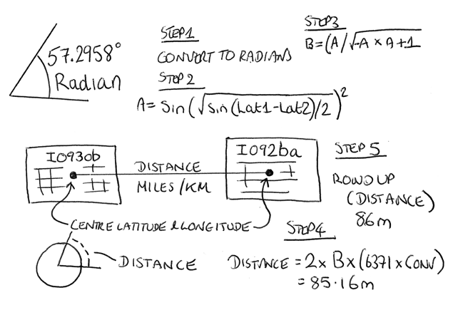
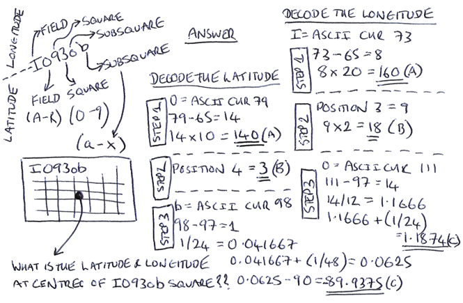
This post shows the step by step process of calculating the distance as the crow flies between two points using latitude and longitude of both points. I have used this calculation in logging software I have been continuously developing the last three years.
How to convert Maidenhead Locator to Latitude and Longitude
This post shows the step by step process of decoding a Maidenhead locator code to calculate the latitude and longitude at the centre of a square. I have used this calculation in logging software I have been continuously developing the last three years.
QSO Heatmap
HEATMAP OF QSO’S FOR AMATEUR RADIO STATION M0NWK
Yesterday I finished developing a function within my custom written logging software that exports QSO details to a ‘QSO Map‘ page on my website. Today I have developed a new function to display a heatmap of these contacts. Find it here
QSO Map
MAP SHOWING QSO’S FOR AMATEUR RADIO STATION M0NWK
Over the last couple of years I have been developing my own logging software. Today I finished a function that exports QSO details to a ‘QSO Map‘ page on my website. Find it here
Live DX Cluster
Real-time spot information by band for active amateur radio operators around the world via the DX cluster network
Over the last few days I have been working on first phase of integrating real-time DX cluster information to my new website so I can view activity on the go.
Taking raw data from a JSON API made available by DXCluster.co.uk , I have developed PHP, CSS and JavaScript that adds styling and automatically refreshes the cluster table every 10 seconds. Thank you to DXCluster.co.uk for the continued use and support of the API.